4. European norms in government, architecture, diet, arts
5. highly urbanized
6. mobile populations
7. high incomes
8. manufacturing output
9. federal states with plural societies
Physical Characteristics
1. Arctic Coastal Plain: In northern Alaska, this is a
complex landscape of lakes, streams and wetlands scattered across low relief
tundra that is underlain by permafrost, an eco-region that is an important
breeding ground for a great deal of wildlife.
2. Canadian Shield: North America contains some of the oldest
rocks on Earth. Its geologic structure is built around a stable platform of
Precambrian rock called the Canadian (Laurentian) Shield. This region was once
an area of high mountains. Centuries of erosion, or gradual wearing away,
reduced the area to low hills and plains rich in minerals.
3. Interior Lowlands: between Rocky Mountains. and
Appalachians ... covered by glacial debris laid by melt water and wind of the
Pleistocene glaciation
4. Piedmont: A plateau region located in eastern US between the Atlantic
Coastal Plain and the main Appalachian Mountains, stretching from New Jersey
in the north to central Alabama in the south. The Piedmont is a
physiographic region of the larger Appalachian region. It consists of the
Piedmont Upland and Piedmont Lowlands sections. It consists of the remnant
of several ancient mountain chains that have since been eroded away and has
historically been a farming area although only moderately fertile.
5. Appalachian Highlands: North America’s older mountain ranges,
including the Appalachians, rise near the east coast. These areas have been
mined for rich deposits of coal and other
minerals for hundreds of years.
6. Gulf Atlantic Coastal Plain: Made up of two sub regions, the Atlantic
Plain and the Gulf Plain. Extends along the east and southeast coasts of the
US from east Long Island to the Rio Grande. Cape Cod and the islands off
southeast Massachusetts are part of this region. Although narrow in the
north, the Atlantic Coastal Plain widens in the south, merging with the Gulf
Coastal Plain in Florida. The Atlantic and Gulf coasts are essentially
coastlines of submergence, with numerous estuaries, embayments, islands,
sand spits and barrier beaches backed by lagoons. The northeast coast has
many natural harbors but south of the North Carolina coast there are few
large bays. A principal feature of the lagoon-lined Gulf Coast is the great
delta of the Mississippi River.
7. Interior Highlands: The Ozark Highlands extend across southern
Missouri and northern Arkansas and into eastern Kansas. Thick with forests,
the region includes mountains that rise more than 2,000 feet. The highest
are the Boston Mountains in Arkansas. Important industries in the region
include forestry, agriculture and mining.
8. Great Plains: between Rocky Mountains. and Appalachians ... extensive
sedimentary surface rising westward toward the Rockies
9. Rocky Mountains: Geologically young and complex system extends into
northwest US from Canada and runs south into New Mexico. There are numerous
high peaks in the Rockies; the highest is Mt. Elbert (14,433 ft). The Rocky
Mountains are divided into four sections: Northern Rockies, Middle Rockies,
Wyoming (Great Divide) Basin and Southern Rockies. Along the crest of the
Rockies is the Continental Divide, separating Atlantic-bound drainage from
that heading for the Pacific Ocean.
10. Intermontane Basins and Plateaus: Called intermontane due to position between the Rockies to the east and the Pacific coast mountain
system in the west. Contains 3 physiographic provinces:
a. Colorado plateau
in the north forms the watershed of the Colombia River.
b. Colorado plateau
in the south has thick sediments and the Grand Canyon.
c. Central
Basin-and-Range country of Nevada and Utah (Great Basin)
contains several extinct lakes from the glacial period and the Great Salt
Lake.
11. Pacific Mountains and Valleys: The coast mountain belt from the
Alaskan Peninsula to Southern California is dominated by a row of high
mountain ranges originating from the contact of North American and Pacific
Plates. The major components include California’s Sierra Nevada, Cascades of
Oregon and Washington, and the chain of highland massifs lining the British
Columbia and southern Alaska coasts. The valleys in this area that contain
dense populations are the San Joaquin-Sacramento Valley (central), the
Cowlitz-Puget Sound and the Fraser Valley.
12. Canada: second-largest country in the world (after Russia), area of nearly
10 million sq. km makes it slightly larger than the US, terrain mostly
plains with mountains in the west and lowlands in the east, climate varies
from temperate in the south, along the US-Canadian border, to subarctic in
the north, permafrost in north restricts development
13. United States: third-largest country in the world, over 9.6 million sq. km
of area, climate ranges from tropical to arctic but most of the US lies in
the temperate zone, great variability in terrain and natural hazards, broad
central plains with hills and low mountains in east
Cultural Characteristics
1.
Indigenous cultures shaped, and were shaped by, the geography of North
America. The first North Americans are believed to have migrated from Siberia,
in northeast Asia, by crossing a land bridge over the Bering Strait. These
populations fanned out southward, to present-day Florida, California, Mexico and
Central America. The legacy of European colonization was devastating for Native
Americans.
2. Leading North American civilizations included the Iroquois, native to
southeastern Canada and the northeastern United States.
3. Many of these early North American cultures were scientifically and
agriculturally advanced. Cultures throughout southern North America harvested
corn, squash, and beans in regular cycles. This sort of agriculture allowed
major civilizations to develop. People were no longer bound to produce food
and shelter for their families — some people could work in the food and
construction industries while others became engineers, artists, and political
leaders.
4. The vastness of the northern part of the continent encouraged other
indigenous communities to live nomadic lifestyles. These cultures did not
establish urban areas or agricultural centers. Instead, they followed favorable
weather patterns, natural agricultural cycles, and animal migrations. The Plains
Indians, for example, followed the seasonal grazing and migration of the
American bison.
5. The environment also impacted the traditional beliefs and social structure of
North American indigenous communities. For instance, the Inuit, native to
the Arctic, were deeply influenced by the aurora borealis, or Northern Lights.
They believed the amazing light displays were images of their family and friends
in the afterlife, the souls of animals and spirits, and visual guides for
hunting. Inuit also believed that all things have souls, and that spirits
existed to protect those souls. By respecting the ecosystem (the living and
nonliving things in an environment), Inuit communities aimed to maintain a
balanced existence.
6. Northern Frontier: most of British Columbia, Alberta, Saskatchewan,
Manitoba, Ontario, Quebec and Newfoundland; Yukon Territory, Nunavut
Territory, Northwest Territory, Alaska ... Covers 90% of Canada and all of
Alaska consisting of very harsh weather. Contains one of the Earth’s
storehouses of mineral and energy resources because of the Canadian Shield
covering ⅔ of the eastern part.
7.
French Canada: southern Quebec and northern New Brunswick ... Narrow
rectangular farms, long lots, laid out perpendicular to the St. Lawrence
allowing each farm access to transportation.
8.
Maritime Northeast: Maine, New Hampshire, Vermont, Nova Scotia, New
Brunswick, eastern Newfoundland ... Development has centered on fishing and
recreation tourism in the winter.
9. Core: centered around major urban areas: southeast Ontario
(Toronto), southern Michigan (Detroit), southeastern Wisconsin (Milwaukee),
Illinois, Indiana, Ohio, Pennsylvania, Maryland, Washington DC, northern
Virginia, New York, New Jersey, Connecticut, Rhode Island, Massachusetts ...
Leader during the century between the Civil War and the close of the
industrial age. Still the geographic heart in which manufacturing is
important.
10.
South: Arkansas, Mississippi, Louisiana, Alabama, Tennessee, Georgia,
Florida, North Carolina, South Carolina, southern Virginia, West Virginia,
and Kentucky ... Many problems surrounded the South after the Civil War but
the growth of beef, soybeans, poultry and lumber has helped the growth of
this region. There are still poverty and economic problems. One positive
aspect is many are retiring to areas of the South.
11. Continental Interior: eastern Colorado, Oklahoma, Kansas, Nebraska,
eastern Wyoming, eastern Montana, southeastern Alberta, southern
Saskatchewan, Manitoba, Ontario, South Dakota, North Dakota, Minnesota,
Iowa, Missouri, most of Wisconsin, and northern Michigan ... Agriculture is
predominant, especially wheat and corn.
12. Southwest: Arizona, New Mexico, Texas ... A bicultural regional
complex sometimes referred to as tri-cultural to include not only Anglo
Americans and Hispanic Americans, but also Native Americans. Rapid
development is based on a three prong foundation: (a) availability of
electricity (b) sufficient water for large numbers in dry environment (c)
autos for people to spread out further. The Dallas/Ft Worth - Houston - San
Antonio triangle has become one of the most productive post-industrial
complexes, specializing in business information, health care services and
high tech manufacturing.
13. Western Frontier: Nevada, Utah, Idaho, eastern Oregon and Washington,
western Montana, western Colorado, western Wyoming, southeastern British
Columbia, and southwestern Alberta ... Stretches east-west between the Rocky
Mountains and the Sierra Nevada Cascades, the north-south reaches from Grand
Canyon country to the Canadian Rockies. The Las Vegas Valley is the fastest
growing area in the western frontier due to advances in technology and
communication.
14. Pacific Hinge: California, western Oregon and Washington, and
southwestern British Columbia ... consists of the Pacific coastlands of the
US and Canada. It has good climate and weather. The land is very productive
in California’s Central Valley. Accommodations for large population and
economic growth came after the WWII era. Environmental hazards such as
droughts, flooding, mudslides, brushfire and earthquakes, occur in this
area.
Demographic Characteristics
1. European expansion: Beginning with the Vikings’ brief stint in
Newfoundland circa 1000 CE and continuing through England’s colonization of
the Atlantic coast in the 17th century, which laid the foundation for the
US, European expansion spanned an entire millennium and involved a wide
array of European powers, all of which contributed to the demographic
history of North America.
Three
settlement stages for Europeans:
a. Stage 1 (1600 - 1750): European colonial
footholds on East Coast (French, English, Dutch, Spanish, enslaved Africans)
b. Stage 2 (1750 - 1850): Infilling better eastern farmland, including Upper
Ohio and Tennessee Valleys, Interior Lowlands, Midwest, Interior South;
Canadian settlement slower
c. Stage 3 (1850 - 1910): Westward movement (immigrants and American-born
Europeans) heading for gold rushes and other opportunities
2. Canada's population: relatively low compared to size, of European stock with
the largest group (40%) of British Isles origin and the next largest (27%)
French, two
official
languages -- English and French, 45% is Roman Catholic and the rest are mostly
other Christian denominations with the United Church and Anglican sects as the
largest groups, social development is high as evidenced by an average life
expectancy of approximately 80 years. The majority of Canadians live in an
east/west direction within 200 miles of the border, with the majority living on
the Atlantic side of the country. The Canadian population has evolved slower
than the US. In 1886, the completion of the transcontinental Canadian Pacific
Railway sparked a period of settlement in the far west and the Prairie
Provinces.
3. US population: mostly white with a 12.4% black population, over 80%
Christian (56% Protestant, 28% Roman Catholic), principal language is
English but a sizable minority speaks Spanish. The greatest population
density in the US is along the Atlantic coast, especially toward the north.
The largest settlement agglomeration is known as the Megalopolis, which
reaches from Washington to Boston. The US population is still being shaped
by the wide spectrum of immigrant groups. Blacks, Hispanics, Asians, Pacific
Islanders, American Indians, and Eskimos or Aleuts make up about 27% of all
Americans. The number of immigrants living in the US has almost tripled
since 1970. Most of the Hispanic population is located around New York.
Economic Characteristics
1. wealth of industrial, fuel and agricultural resources
2. postindustrial
a. 300 days of sunshine per year
b. affordable housing
c. low risk business environment
i. tax breaks
ii. cooperative state
and local governments
iii. lenders
iv. businesses
d. economic enterprises
e. government
f. social-services complexes
g. military
3. Canada: a market-oriented economic system ... largely rural prior to WWII but
growth in manufacturing, mining and service sectors has transformed the
nation into one that is primarily industrial and urban ... most electric power
is hydroelectric with significant amounts produced by fossil fuels and
nuclear energy ... main exports include motor vehicles and parts, wood and
paper products, fossil fuels and machinery ... main imports are machinery and
equipment, crude oil, chemicals, motor vehicles and parts and durable
consumer goods ... US is major trading partner due in part to NAFTA which also
includes Mexico ... has a well-developed infrastructure that includes railways,
highways, waterways, pipelines for oil and natural gas, airports and
heliports
4. US: most powerful, diverse and technologically advanced economy in the
world ... market-oriented economy in which private individuals and business
firms make most of the decisions ... government buys needed goods and services
predominantly in the private marketplace ... electricity production is from a
variety of sources but over 60% is from fossil fuels and less than 20% from
nuclear power ... exports capital goods, automobiles, industrial supplies and
raw materials, consumer goods and agricultural products ... imports crude oil
and refined petroleum products, machinery, automobiles, consumer goods and
industrial raw materials ... over 60% of trade is with Canada, Western Europe,
Japan and Mexico ... has a well-developed infrastructure that includes
railways, highways, navigable waterways, the Great Lakes, numerous ports and
harbors, airports and heliports
Political Characteristics
1. Cooperation and conflict have dramatically affected
the relationships between North American countries. The US and Canada have
the longest non-militarized border in the world, for instance. This peaceful
border reflects a stable, cooperative relationship between the two
countries. North America’s history is dotted with conflict, however. The
region has become a hotspot for foreign policy and financial assistance.
Over the years, the US, for instance, has hoped to protect its economic and
political interests by backing various military governments and guerrilla
groups.
2. North America’s political geography is deeply influenced by
economic and demographic trends. Immigration is perhaps the most
sensitive aspect. Most immigration is fueled by poverty.
3. National security at the international, regional and
domestic level will continue to be an important issue. Internationally, the
developed countries of North America, especially the US, continue to
negotiate their diplomatic presence in the world while protecting themselves
from terrorist attacks at home.
4. One of the most important aspects of North America’s
political and financial future rests largely on its efforts to minimize the
effects of climate change.
You may note that for some countries on the Americas, Africa, Europe and Russia,
and Asia and the Pacific pages I have provided a link to one or more of that
county’s EarthCams. The cameras are live so what you see depends on when you
watch it. They also have sound. A few of the views have a brief commercial at
the beginning and occasionally a few may be off-line. Just try the latter at a
later time. You can click on the Hall of Fame link at the top of each
video and see scenes from the past few days. If you are interested in watching
cams I haven't listed on these pages, feel free to check out the
EarthCam Network. Beware: Watching live EarthCam can be hypnotic!
Bermuda
|
Bermuda
is a
British overseas territory
in the North Atlantic Ocean, off the east shore of North America about 655 miles
east-southeast of Cape Hatteras, NC. Bermuda's economy is based on offshore
insurance and tourism, its two largest economic sectors. Bermuda had one of the
world's highest GDP per capita for most of the 20th century and several years
beyond. Recently, its economic status has been affected by the global recession.
The island is in the hurricane belt but is somewhat protected by the
coral reefs that surround
it. Bermuda is the northernmost point of the
Bermuda Triangle, a region
of sea in which, according to legend, a number of aircraft and surface vessels
have disappeared under supposedly unexplained or mysterious circumstances.
|
Bermuda: The Definitive Guide
|
Tour the Royal Naval Dockyard
(9:10)
|
B.R.E.A.M. |
Bermuda Cam
For
centuries, explorers searched in vain for the fabled Northwest Passage, hoping
that they could find a navigable route through the Arctic pack ice that would
allow merchant ships to quickly sail between the Atlantic and Pacific Oceans.
Such a route proved elusive until famed Norwegian explorer Roald Amundsen
made the first complete passage through the icy waters north of Canada back in
1906. It took him three years to prove the Passage existed, however, and at the
time it was not a commercially viable path. Today, however, climate change has
reduced the amount of ice that chokes those waterways, allowing ships to pass
through between July and September each year. Thanks to global warming, this
once mythical route has become a reality and the Northwest Passage becomes
increasingly easier to navigate with each passing summer. In fact, in 2016 it
was almost completely free of ice.
Toronto, Canada
is the largest Canadian city and the fifth largest city in North
America. Toronto is heralded as one of the most multicultural cities in the
world and is ranked as the safest large metropolitan area in North America. Over
140 languages and dialects are spoken here, and just over 30% of Toronto
residents speak a language other than English or French at home. Toronto is not
the political capital of Canada but it is the cultural, entertainment and
financial capital of the nation. It is located in Southern Ontario on the
northwestern shore of Lake Ontario. A relatively modern city, Toronto's history
dates back to the late 18th century, when its land was first
purchased by the British monarchy from the Mississaugas. Walking on the streets
of Toronto it is almost impossible to believe that there is a second city – PATH
– hidden underground. According to Guinness World Records, PATH is the world’s
largest underground shopping complex with 17 miles of shopping arcades. It has 4
million square feet of retail space. The 1,200 shops and services found in
PATH employ about 5,000 people. Once a year, businesses in PATH host the world's
largest underground sidewalk sale. |
Toronto Cam
Icebergs of Greenland: Greenland is the world's largest non-continental island with a territory of
1,324,017 square miles. The shores are carved by deep long fjords, reaching
the edge of the ice sheet. The glaciation of Greenland's territory began during
the anthropogenic period (a geological period that started 2,588 million years
ago). Today the ice sheet covers 1,139,594 square miles of the island,
creating the unique Greenland scenery. The cold East-Greenland current washes
over the east coast of Greenland. Floating icebergs block the entire east coast
almost all year round. The water off the north coast is constantly covered with
ice, and the only relatively warm area is the southwest coast, thanks to the
warm West-Greenland current. |
Yes, Greenland’s ice is melting but… |
How Much Ice Is Greenland Losing? The island is shedding 20% more than
previously estimated, potentially threatening ocean currents that help regulate
global temperatures.
There are lots of pictures so it may take a minute for the
page to open!
Comparing Countries
Middle America (Central America and the Caribbean
Basin)
Major Geographic Qualities
1. Mexico, Central America, Caribbean Islands
2. physically and politically fragmented
3. culturally diverse
4. endemic poverty
Physical Characteristics
1. Central America is a land bridge
with a chain of rugged mountains extending through the
center. These towering mountains rise as high as 14,000 feet, with the
highest in Guatemala. On each side of these highlands exist lowlands along
the Atlantic and Pacific coasts (with the exceptions of El Salvador, which
does not border the Atlantic, and Belize, which does not border the Pacific). The lowlands are generally hot, humid and
often plagued by disease, while the highlands are cooler and drier.
2. Situated largely on the Caribbean Plate, the Caribbean Basin region is comprised of more
than 700 islands, islets, reefs and cays. (See map thumbnail above for
this discussion.) These islands generally form island arcs that delineate
the eastern and northern edges of the Caribbean Sea. The Caribbean islands,
consisting of the Greater Antilles on the north and the Lesser Antilles on
the south and east (including the Leeward Antilles), are part of the
somewhat larger West Indies grouping, which also includes the Lucayan Archipelago (comprising The Bahamas and Turks and Caicos
Islands) north of the Greater Antilles and Caribbean Sea. In a wider sense,
the mainland countries of Belize, Venezuela, Guyana, Suriname and French
Guiana are also sometimes included.
The Caribbean is divided into two main subdivisions: the
Greater Antilles (Cuba, Jamaica, Hispaniola [Haiti and the Dominican
Republic] and Puerto Rico) and the Lesser Antilles. Within the Lesser
Antilles, there are three sub-groupings: the Leeward Islands, the Windward Islands
and the Leeward Antilles. Early sailing ships
crossing the Atlantic took advantage of the trade winds and ocean currents.
These often delivered them to the edge of the Caribbean Sea near Dominica.
The Windward (direction upwind from the point of reference) Islands were so
named because they were more windward at this location than the Leeward
(direction downwind or downward from the point of reference) Islands.
1. Two of the most important civilizations to have flourished were the
Mayan and Aztec Empires. Both possessed complex
societies and high levels of technology. The
Mayan Empire first rose more than 3,000 years ago and occupied the low-lying
tropical plains of what is now Honduras, Guatemala, Belize and southern Mexico. The
Aztec Empire, which came much later, is thought to have originated in the
early 14th century. This empire stretched from Honduras to the highland areas of
central Mexico, its core being in the great city of Tenochtitlan in the Valley
of Mexico, the area that is today Mexico City. The Aztec civilization lasted
approximately 100 years until
Hernán Cortés, the
Spanish Conquistadors and an epidemic of
smallpox, effectively
destroyed the Aztec Empire in the 1520s.
a. Maya cultural hearth
i.
classical period 200-900 CE
ii.
Honduras, Guatemala, Belize, Yucatan peninsula
iii.
theocratic structure
b. Aztec cultural hearth
i.
1300 CE
ii.
Valley of Mexico
iii. Tenochtitlan (>100,000 people)
2. Multiple influences have overprinted the indigenous cultures.
Four main colonial influences:
a. Spanish: dominant on the inland portions of the mainland and
large islands
b. British: coastal areas of the mainland and islands
c. French: islands
d. Dutch: islands
3. legacy of colonialism
a. land appropriation
i. Land was appropriated for colonial commercial interests, resulting in a very
unequal distribution of land ownership and income.
ii. Lands devoted to food crops for local consumption were converted to cash
crops for export.
b. forced urbanization: relocation of the population to nucleated towns
and villages, favored control and conversion to Catholicism
c. land alienation: characterized by famine (loss of 90% of population),
poverty, migration, little agricultural diversity
i. implementation of the encomienda: replicate of the European feudal
system that mandated the payment of tributes to the Crown, forced indigenous
groups into the cash economy
ii. formation of large haciendas (estates): Crown rewarded
conquistadores with huge land grants (including much land already used by
the indigenous peoples) with natives tied to land, most provided protection and
the teachings of Christianity … system ensured the presence of a large labor
force that essentially was a slave labor force, with workers deriving little
benefit from their labors beyond the ability to pay the encomienda … not
efficient but brought social prestige to land holders
iii. ejidos system: hacienda system was broken up and
most hacienda-land was given back to the people, often in the form of an
ejidos
system (land system in which the community owns the land but individuals can
gain profit from it by sharing resources) … system has created its own set of
problems and many communally-owned lands are being transferred to private owners
d. Presence of the Catholic Church is felt virtually everywhere in Latin
America today. In most of these countries, the Catholic population ranges from
80 to 90%. Forcing the indigenous population to accept Catholicism was not an
easy task for the Spaniards. One thing that made conversion easier was that
Catholicism has many saints and the indigenous religions have many gods. For
many indigenous peoples, Catholicism has been mixed with indigenous religions to
form a combination of the two (religious
syncretism).
Cuba’s massive Carnival celebrations have been held
in some form or another since the 17th century. As a series of winter events
tied to the Catholic Church’s calendar, Carnival was largely reserved for Cubans
of mostly Spanish ancestry, while its summer counterpart, the Mamarrachos,
allowed laborers and the lower classes (mostly enslaved Africans and their
descendants) a period of riotous release after the sugar cane harvest. Many
other Carnivals across the Caribbean are still observed in February, before
Lent, but Cuba’s Carnival has evolved into an exuberant summer event that is
celebrated across the country. The most famous parties, held in Havana in August
and in Santiago de Cuba at the end of July, have preserved the vibrant spirit
and Afro-Caribbean influences of the original Mamarrachos. Spangled and
feathered groups of dancers called comparsas perform in the streets
between giant effigies of religious figures and celebrities, decorated floats
and conga performers. The mainstreaming of festivals that originated from
marginalized communities hasn’t been entirely seamless, with periodic attempts
by conservative Cubans to sanitize them, but the omnipresent rhythm of the
Carnival drums is a permanent reminder of their roots in resilience, triumph and
pure joy.
e. Mainland and Rimland characteristics of Middle
America based on colonial-era economic activities … Both the hacienda and the
plantation structures of agriculture altered the ethnic makeup of their
respective regions.
i. mainland: the interior of Central America and Mexico …
Euro-Indian influence, mestizo, greater isolation from
European activity, mountains, altitudinal zonation climate (natural layering
of ecosystems that occurs at distinct altitudes due to varying environmental
conditions), hacienda landholding pattern
ii. rimland: Caribbean islands and the Caribbean coastal
areas of Central America … Euro-African influence, mulatto,
greater accessibility to European ships, islands, tropical climate,
plantation landholding pattern … For example, sugar production had large
economies of scale (large plantations with hundreds of slaves, large capital
requirements) and resulted in high concentration of wealth and land
ownership.
4. Caribbean Indians: A number of indigenous groups inhabited the
Antilles before the arrival of Europeans, including the Arawaks, Caribs and the
Tainos
(the latter thought to have been descended from the Arawak tribe). Beginning
with the Columbus expedition of 1492, European presence has had a dramatic
effect on the demographic character of the Caribbean. Spanish brutality,
enslavement, warfare and disease all contributed to the rapid decline of the
indigenous Amerindian population. This left a critical labor shortage for the
fledging sugarcane industry, thus prompting Europeans to actively seek and
obtain slaves and indentured labor from Africa and Asia respectively. No less
than five million Africans were brought to the Caribbean alone.
5. African Slave Trade:
African slaves primarily came from
West Africa where they were forcibly removed from their native lands and
taken to the Americas by
European slave traders. Tribal groups were rarely, if ever, left intact upon
reaching their new home. Instead they were intentionally mixed to dilute ethnic
identities. As a result, intact transfer of religion and languages into the
Caribbean did not occur, which consequently provided conditions for new dialects
and cultures to arise.
Demographic Characteristics
1. social stratification
a. development of a socially stratified society along racial lines
b.
miscegenation: mixed race resulting between Caucasians and the indigenous
population … began very early on during the colonial period since early
migrations from Europe were primarily male
c. in most cases continued into contemporary times … one of the overriding
realities of Latin America … one of the region's greatest problems
2. diversity: European and African influence, less Latin than South
America, importance of pre-Columbian and African cultures, many European
dominions (English, French, Dutch), sizeable Asian minorities in some countries
… Caribbean changes: entirely Amerindian, dominated by European
colonizers, an African majority population … Central America/Mexico changes:
mixing of European culture with Amerindian culture to form various types of
mestizo (people of mixed ethnicity) groups with Hispanic, Latino or Chicano
identities
3. Euro-Indian vs. Euro-African: mestizos (métis) (European /
Indian), mulattos (European / Black) … tend to follow a mainland-rimland
pattern
4. Middle America’s climates and landscapes have a large impact on settlement
patterns in the region. (In Latin America as a whole, most of the population
lives on only one-third of the land.)
a. Mexico: largest concentrations in Mexico City area, with sizeable
indigenous concentrations in southern Mexico
b. Central America: most in middle altitudes and along Pacific coast …
Atlantic coast less settled due to lowlands, tropical rainforest, infertile
soils, tropical storms
c. Caribbean: most concentrated populations generally along coasts …
because of these countries’ small sizes, tend to have high population densities
5. Middle America has faced problems in past decades with
soaring population growth and economies and infrastructures that
struggled to keep up with the rising population. However, in recent years,
population growth rates have dropped dramatically. Yet aggregate numbers
do not reflect the variation in birthrates between various countries. The most
extreme variation can be found in Cuba and Guatemala which respectively have the
lowest (1.47) and highest (3.98) fertility rates in Middle America. Cuba faces a
rapidly aging population, while Guatemala has seen an increase in younger
working-age adults. Look at the regional
population pyramids (above right). Population pyramids are used by
demographers as a tool for understanding the make-up of a given population. They
are graphs that show the age-sex distributions of different populations. Sex is
shown on the left/right sides, age on the y-axis, and the percentage of
population on the x-axis. Each grouping (ex: males aged 0-4) is called a cohort.
A population pyramid does not tell you the actual population in numbers. Rather,
it displays percentages and shows what portion of a population fall into each
cohort. In general, the more rectangular the graph is shaped, the slower a
population is growing (a more uniform population size across age groups with older
generations being replaced by new generations of approximately the same size).
The more a graph looks like a pyramid, the faster that population is growing
(older generations are producing larger new generations).
6. Internal migration (especially rural-to-urban) and regional migration
(predominately for economic reasons) are increasing.
7. Poverty: Share of the region's population in extreme
poverty is falling. Middle class is growing. Still an awful lot of people in
extreme poverty … largest single group of people in the region is the
“vulnerable” and at risk of slipping back into poverty if their fortunes change.
Income disparities have improved but remain high. (All countries in Latin
America are more unequal than Turkey, the most unequal OECD country from outside
the region.) Indigenous communities are particularly vulnerable to
poverty. Natural disasters have aggravated poverty in the region.
Economic Characteristics
1. NAFTA (1994) trade agreement between Mexico, Canada and the US:
reduced and regulated trade tariffs, barriers and quotas … standardized finance
and service exchanges … advantages: Mexico gained jobs, foreign owners benefitted
from cheaper labor costs … effects: regional development, development of an
international growth corridor between Monterrey and Dallas - Fort Worth …
future: model came to a standstill in 21st century due to labor competition from
China ($0.35 to $1 per hour), loss of 300,000 jobs
2. Mexico and NAFTA: promised a higher standard of living. NAFTA created
more jobs for Mexicans as US companies began to invest more heavily in the
Mexican market. Mexican exporters increased their sales to the US and Canada.
Canada remained the United States’ largest export market. Since 1977, Mexico
moved into second place (displacing Japan). 85% of all Mexican exports now
went to the US. 75% of Mexico’s imports originated in the US.
3. USMCA: In early 2020, Congress approved the United States–Mexico–Canada Agreement
(USMCA) as a replacement for NAFTA. Some critics have
complained that the new agreement amounts to government-managed
trade. However, the USMCA is very similar to NAFTA, carrying over many of
the same provisions and making only modest, mostly cosmetic changes and is
expected to make only a minor economic impact. Labor has criticized the labor
standards in the USMCA as unenforceable and toothless. It is feared that a
measure that expands the patent length for biological substances to 10 years,
thus limiting access for new generic drugs to enter the market, will make it
harder to bring down drug prices. It is also feared that the data and IP
provisions of the USMCA run the risk of turning Canadian firms into "data cows"
of foreignbig data.
4. CAFTA: The goal of the Dominican Republic-Central America-US Free
Trade Agreement (2005) or CAFTA-DR is to eliminate tariffs
and promote market access for the participants, which include Costa Rica, the Dominican Republic, El Salvador, Guatemala, Nicaragua
and the US.
5. tropical deforestation in Central America: 3 million acres of woodland
in Central America disappear each year ... causes: clearing of rural lands to
accommodate meat production and export, rapid logging of tropical woodlands to
meet global demands (new housing, paper and furniture), population explosion
(cut to provide crop-raising space and firewood)
6. tourism: Caribbean countries are small with limited agricultural
potential and economic opportunities. Yet the increased cost of acquiring goods
for purchase keeps the costs of living high ... advantages of tourism: state and
regional economic options, a clean industry, educational ... disadvantages:
disjunctive development, degrades fragile environmental resources, inauthentic
representations of native cultures
1. In general, the struggle for power between Liberals and Conservatives has
dominated politics during most of post-independence history. As their name
suggests, conservatives are generally resistant to change that would threaten
their favored position in society. They favor monarchies and strong central
governments. Liberals, on the other hand, emphasize the importance of reason and
favor republics with greater democracy. Liberals have sought to reduce the
importance, wealth and political power of the Catholic Church, and support
greater freedom of religion. Conservatives have sought to maintain the church’s
privileged position. They also favor economies dominated by a few large
monopolies (power and status quo), while liberals favor a more competitive
marketplace and free trade.
2. The Cold War complicated matters in Middle America as the Soviet Union and
the US competed for influence throughout the region. The US did not want Middle
American countries governed by rulers it perceived to be friendly to the
Soviets. The US feared that if Middle American governments became communist, the
rest of Latin America would become communist (the domino theory), including
Mexico, which borders the US. Because of this, the US has consistently supported
(politically, economically and militarily) conservative authoritarian leaders
throughout the region. The result has been a region dominated by powerful
dictators and the relative absence of democracy.
iii. The
Netherlands Antilles dissolved on
October 10, 2010. Curaçao and Sint
Maarten (the Dutch two-fifths of the island of Saint Martin) became
autonomous territories of the Kingdom of the Netherlands. Bonaire, Saint
Eustatius and Saba (BES)
now fall under the direct administration of the Netherlands.
Mexico | The Aztecs founded
Mexico City in 1325 A.D.
Spanish conquistadors led by the legendary Hernán Cortés conquered it two
centuries later. In fact, the combination of ancient Indian traditions and young
European ambitions is what makes the modern capital of Mexico unique. All of
Mexico City's contrasts – high crime rates vs. local hospitality, ultra modern
skyscrapers vs. Aztec pyramids, slums vs. magnificent palaces, hills vs. plains
— provide the city with a special unforgettable atmosphere. |
The Oldest Surviving Book in the Americas |
Ocomtún: A long-lost Maya city that was just discovered
The ancient city of
Chichen
Itza,
located in the northern part of the Yucatan Peninsula in Mexico, was founded in
the 7th century CE during the golden age of Mayan culture. One of the
key structures in Chichen Itza is the Temple of Kukulkan, a 79-foot-high pyramid
built for the Supreme God of the Wind and Rain, and the founder of royal
dynasties and large cities. The Maya depicted Kukulkan as a feathered serpent
with a human head. This is why a feathered serpent appears in the Temple of
Kukulkan on every spring and autumn equinox. At about 3 pm on those days, the
sunlight casts a series of shadows against the western balustrade of the main
stairway, creating an optical illusion of a 121-foot-long snake that follows the
sun wriggling down to its own head carved at the base of the staircase … a
unique collaboration of nature and architecture.
|
Sacred Sites of Mexico |
Swimming with the sea lions of Los Islotes |
Intimate Portraits of Mexico’s Third-Gender
Muxes|
An Intimate Look at Mexico’s Indigenous Seri People
Guatemala
|
Maya Pyramids, Tikal, Guatemala: The first Mayan settlements were established on the continent of North America
around 2000 BCE. This ancient civilization greatly influenced history with its
writing, art, architecture, mathematics and astronomical systems. Tikal was
originally known as Yax Mutul; that is how it's referred to in hieroglyphic
inscriptions. From the 1st to the 9th century, Yax Mutul
was the capital of the Mutul Kingdom. The city reached its apogee in 600 to 800
CE with a population of perhaps 90,000 people. Then, at the end of the 10th
century and for unknown reasons, it suddenly went into decline and was engulfed
by the surrounding jungle. The city – an area greater than 6 square miles –
has been completely mapped. It contains about 3000 structures, including various
palaces, the Acropolis, funeral ritual grounds and even a prison. Many of the
ancient structures have not yet been excavated.
|
Sacred Sites of Guatemala | Anticorruption
campaigner Bernardo Arévalo, the most progressive Guatemalan leader in decades,
won the 2023 presidential election in a landslide but
faces a barrage of legal attacks aimed at preventing an orderly transfer of
power. |
Guatemala’s new president is sworn in, despite efforts to stop him.
Honduras was home to several important
Mesoamerican cultures, most notably the
Maya, before the Spanish invaded in
the
sixteenth
century. The Spanish introduced Roman Catholicism and the now predominant
Spanish language, along with numerous customs that have blended with the
indigenous culture. Honduras became independent in 1821 and has since been a
republic, although it has consistently endured social strife and political
instability, and remains one of the poorest countries in the Western Hemisphere.
Honduras has the
world's highest murder rate.
|
Honduras News
|
Sacred Sites of Honduras
|
Tegucigalpa
|
The Mystery of the Healthy Coral Reef
The name
Nicaragua was coined by Spanish
colonists based on the name of the chief of the most populous indigenous tribe
in the 1500s. Those colonists settled along Lake Nicaragua, the largest of
several freshwater lakes in southwestern
Nicaragua and the dominant physical
feature of the country. It is also the largest lake in Central America. It
is believed that
Lake Nicaragua, together
with
Lake Managua to the
northwest, originally formed part of an ocean bay that, as a result of volcanic
eruption, became an inland basin containing the two lakes, which are linked by
the
Tipitapa River. The ocean
fish thus trapped adapted themselves as the salt water gradually turned fresh.
Lake Nicaragua is the only
freshwater lake containing oceanic animal life, including sharks, swordfish, and
tarpon. |
LANIC Nicaragua |
Culture |
Nicaragua Canal
|
Nicaragua Canal 2
|
A Guide to Lake Nicaragua's Islands
|
Sacred Sites of Nicaragua
Hurricanes represent one of the most important weather-related threats to
the environment of this region. The islands of the Caribbean, with their low
elevation, are particularly vulnerable to these impressive super-storms. The
sheer power exerted in only a matter of hours by a
hurricane can reshape the environment of an island for many years after the
event. Strong winds, high volumes of precipitation and tremendous coastal surges
all contribute to the destructive power that these storms are known to produce.
Whether it is the
Dominican Republic,
Jamaica or the
US Virgin Islands, a trip to the beaches and ecosystems of the Caribbean
makes it clear why the Caribbean has become a popular vacation destination for
millions each year.
Anguilla
(4:59), a
British overseas territory
in
the Eastern Caribbean, includes a small
main
island and several offshore islets … the first in the chain of the
Leeward Islands. Protected areas include
Big Spring Cave, known for its prehistoric petroglyphs, and
East End Pond
(3:13), a wildlife conservation site.
Fountain Cavern is the Eastern Caribbean’s most intact ceremonial
site from ancient times and features petroglyphs, offering bowls and a
stalagmite carved in the likeness of Jocahu, the Supreme Deity of the
Arawak people. The Caribs, a tribe of cannibals, captured the island
from the peaceful Arawak tribe and completely eradicated them. The earliest
Amerindian artifacts found on
Anguilla have been dated to around 1300 BCE, and
the remains of some settlements date from 600 CE. Those influences and the
influences of the colonial era have made Anguilla a
melting pot of cultures. Today, tourism is the major industry. |
Nature Explorers Anguilla|
Anguilla Cam
Aruba is a
constituent country of the Kingdom of
the Netherlands in the southern Caribbean Sea, located about 990 miles west of
the main part of the Lesser Antilles and 18 miles north of the coast of
Venezuela. It measures 20 miles long
from its northwestern to its southeastern end and 6 miles across at its widest
point.
Aruba is one of the four countries that form the
Kingdom of the Netherlands, along
with the Netherlands, Curaçao and Sint Maarten. Unlike much of the Caribbean
region, Aruba has a
dry climate and an arid, cactus-strewn
landscape. It is a generally
flat, river-less island
with white sandy beaches on the western and southern coasts of the island,
relatively sheltered from ocean currents. |
Aruba Cam
Grenada
consists of the main island and smaller
surrounding islands, including
Carriacou and Petit Martinique. Most of the population lives on
Grenada, which is also home to the capital,
St. George's,
whose colorful homes and Georgian buildings overlook narrow Carenage Harbor.
The islands are of
volcanic origin with
extremely rich soil. Grenada's interior is very mountainous and several small
rivers with beautiful waterfalls flow into the sea from these mountains. The national bird of Grenada, the
Grenada dove, is found only on
Grenada and is one of the most critically endangered doves in the world. Grenada
is known as the
Island of Spice because of the
production of nutmeg and mace crops, of which it is one of the world's largest
exporters. Grenada's modern
focus, however, is tourism. |
Grenada Marine Protected Areas
The
Soufriere Hills, Montserrat, West Indies site is maintained by the Michigan Technological University as part of
their volcano monitoring activity around the world. The Soufriere Hills volcano
on the Caribbean island of Montserrat has been very active in recent years. This
site contains links to information about the volcano itself, as well as many
images of the volcano in various stages of eruption. Additionally, there are
links to the Montserrat Tourist Information Board, a good site that illustrates
the impact of geography on people since much of the island has been evacuated
due to the volcanic activity.
The Federation of
Saint Kitts and Nevis, also
known as the Federation of Saint Christopher and Nevis, is a two-island country
located in the Leeward Islands chain of the Lesser Antilles. It is the smallest
sovereign state in the Americas, in both area and population. The country is a
Commonwealth realm, with the British monarch as head of state.
St. Kitts and
Nevis were among the first islands to be occupied by
Europeans. Today, the
economy is dependent on
tourism, agriculture and small manufacturing industries. The islands also
provide fantastic diving sites due to abundant
marine life. A major sugar
exporter for centuries, the large plantations are now beautiful estates that
have been converted into hotels and resorts.
|
St Kitts and Nevis
St. Lucia | Although many thousands of St. Lucians
have emigrated to various parts of the Americas and Europe, especially during
the 20th century, their identification as St. Lucians remains strong,
even among those born in the diaspora. The question of a
shared culture is contentious, for
Saint Lucians are divided along many lines, yet there is a strong sense of
belonging to a
place, a locality, of which they have
a sense of possession.
|
History |
Local Citizens Leading Coral Restoration Effort in St. Lucia |
Economy |
St Lucia
With a GNI per capita of $14,400,
Trinidad and Tobago is one of the wealthiest and
well-developed nations in the Caribbean … although it
still has problems. In November 2011,
the Organization for Economic Cooperation and Development removed Trinidad and
Tobago from its list of developing countries. Trinidad’s economy is strongly
influenced by the
petroleum industry. Tourism and
manufacturing are also important to the local economy. Tourism is a growing
sector, although not proportionately as important as in many other Caribbean
islands. Agricultural products include citrus, cocoa and others.
|
Breathless in Trinidad and Tobago (25:25) and
The Black Diamond: Lake Asphalt (7:16) are two excellent
videos on Trinidad and Tobago.
There are lots of pictures so it may take a minute for the
page to open!
South America
Major Geographic Qualities
1. population concentrated along periphery
2. cultural pluralism
3. minimal regional economic interaction
Physical Characteristics
1. South America can be divided into three physical regions: mountains and
highlands, river basins, and coastal plains. Mountains and coastal plains
generally run in a north-south direction, while highlands and river basins
generally run in an east-west direction.
a. mountains and highlands: primary mountain system situated on the far
western edge of the continent, the
Andes, is also the world’s longest (5,500 miles) … highest peak (22,841
feet),
Aconcagua, is tallest mountain outside Asia …
altiplano of Peru and Bolivia …
Patagonia region of Argentina and Chile consists of lower-elevation plateaus
and rugged glaciers …
Brazilian Highlands, south of the Amazon River in Brazil, are made up of low
mountains and plateaus … heavily forested plateau of the
Guiana Highlands located between the Amazon and Orinoco Rivers
b. river basins:
Amazon basin (2.7 million square miles) in the central north fed by
tributaries from the
glaciers of the Andes (The glaciers are melting so quickly, it's hard to
find a good current photo.) and defined by
dense, tropicalrain forest (Every second, the
Amazon River empties 7,381,000 cubic feet of freshwater into the Atlantic
Ocean.) …
Paraguay/Paraná basin covers over 1 million square miles and is made up of
vast grasslands, supplies water to the Pampas (plains biome, most important
grazing and cropland areas on the continent) of South America, includes
Iguazu Falls (a massive series of waterfalls) …
Orinoco basin a giant arc north of Amazon for more than 1,700 miles and
covers an
area of about 366,000 square miles, the
Llanos (a vast savanna or grassland region) is primary biome of the Orinoco
River basin
c. coastal plains: areas of low, flat land next to a seacoast … found on
the
northeastern Atlantic coast of Brazil and the western Pacific coast of Peru
and
Chile … both extremely dry, western coastal plain includes
Atacama Desert (driest region in the world with average rainfall of 0.04
inches a year, some parts have never had rain in recorded history), a rich
source of copper
d. The Darién
Gap: a sliver of jungle that is the only land route between Central
America and South America, a roadless and lawless crossing on the border
between
Colombia and Panama consisting of more than sixty miles of dense rain forest,
steep mountains and vast swamps. Thick, hot and prone to intense rain and
landslides, sliced by raging rivers and steep mountains, the Darién jungle has
acted as a vast natural barrier between North and South America for generations.
Guerrillas and other armed groups have long used the dense forest for cover and
drug smuggling, sometimes attacking those who dare to pass. Diseases like
malaria and dengue are common. Deep in the jungle, travelers are faced with high
heat and humidity, robbery, rape, human trafficking, wild animals, insects and
the absolute lack of safe drinking water.
2. South America’s extreme geographic variation contributes to the continent’s
large number of biomes (a community of animals and plants that spreads over an
area with a relatively uniform climate). With an unparalleled number of plant
and animal species, South America’s rich biodiversity is unique among the
world’s continents.
Cultural Characteristics
1. Of the civilizations of South America, one of the most important was that of
the
Incan Empire. The empire, which originated around the 13th century and
lasted nearly 350 years, occupied the
highland areas of Peru, Ecuador and Bolivia. The ancient Incan language of
Quechua is still in use in parts of South America today. Agriculture was
extremely important to the native peoples of the region. Their advancements in
farming and crop domestication, which were quickly brought back to the old world
by European explorers, ultimately helped transform modern Europe.
a. cultural
hearth: intermontane basin around Cuzco (1200-1535 CE)
b. altiplano (high plain) key to settlement patterns
c. 12 million population at high point
d. impressive transportation networks and integration efforts:
built an expansive network of roads
including forts, inns, food storage facilities, signal towers
3. The importation of African slaves represented a major shift in the
cultural landscape of South America. Most slaves were brought to Brazil. Their
unique cultural practices were integrated with indigenous Indian beliefs as well
as European rituals.
4. South America’s cultural spheres:
a. tropical plantation
i. resembles Middle America rimland
ii. location, soil, climate favor plantation crops, especially sugar
iii. initially relied on African slave labor
b. European commercial
i. most “Latin” part of South America
ii. includes the Pampas (temperate grasslands)
iii. economically most advanced
iv. excellent transportation networks and quality of life
c. rural Amerindian
i. correlates with former Inca Empire
ii. feudal socioeconomic structure persists
iii. includes some of the poorest areas
iv. subsistence agriculture must contend with difficult environmental challenges
d. mixed Mestizo
i. surrounds Amerindian subsistence region
ii. culturally and agriculturally mixed zone
iii. transitional economies
e. undifferentiated / Amazon
i. characteristics difficult to classify
ii. sparsely populated
iii. notable features: isolation and lack of change
iv. Amazonia development may prompt significant changes.
5.
Columbian Exchange: (Use the thumbnail above right.) contact between the
people, plants and animals of the old and new worlds … Both sides were forever
changed by the introduction of different species … The Spanish and Portuguese
brought a number of crops with them: wheat (flourished in upland areas), grapes
and olives (produced commercially in temperate zones of South America), sugar
cane (became the dominant cash crop of Caribbean and Brazilian tropical
lowlands), coffee (emerged as a large export crop that was cultivated in the
upland areas of Central America, Colombia, Venezuela, Brazil) … a number of
crops were transported to Europe: corn, potatoes, manioc, hot peppers, tomatoes,
pineapple, cacao, avocados … diseases: smallpox, measles, whooping cough,
bubonic plague, diphtheria, influenza … Europeans brought: horses, pigs, sheep,
goats, cattle, rats
Demographic Characteristics
1. urbanization: movement to and clustering of people in towns and cities
(79%)
a. Latin America is the most urbanized of the world’s developing regions. It is
the only developing region with more poor people in cities than in rural areas.
b. Increase based on rate of natural increase and internal migration
(consolidation of lands, mechanization of agriculture, more opportunities in
cities).
c. A number of cities are classified as megacities (more than 10 million
people): Mexico City, Rio de Janeiro, Sao Paolo, Buenos Aires.
d. Urbanization will define the human geography of South America in years to
come. Individuals and families face increasing job insecurity, lower wages and a
reduction in social services such as electricity and water.
2. diversity: largest number of indigenous groups in the world, largest
concentration of Africans outside Africa and of Japanese outside Japan,
creole (African descent who emigrated from British and French colonies in
the Caribbean), large populations of mixed races: mestizo
(European/Indigenous), mulatto (European/African), zambo
(African/Indigenous)
3. population distribution: interior sparsely populated, most live in
upland coastal regions and in cites … During colonial era, preferential
treatment was given to city dwellers, providing a motivation to move to the
cities.
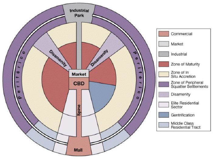
4. Latin
American City Model (Griffin-Ford Model): Latin American cities are built
around a core central business district (CBD). Out of that district comes a
commercial spine surrounded by elite housing. These areas are then surrounded by
three concentric zones of housing that decrease in quality as one moves away
from the CBD. (Look at the illustration of the model by using the thumbnail to
the left.)
a. commercial / CBD: focus of employment, entertainment and economic
activity … Roads, trains and buses are fairly reliable here.
b. spine: connects CBD to retail areas, a corridor of retail that leads
to the mall (formal retail economy, taxed and licensed by the government) on one
end and the market (informal economy, traditional area beyond control/taxation
of government, unlicensed people sell homemade goods and services, may or may
not be legal) on the other
c. industrial park: jobs of those in the middle and lower class, in a
convenient place for those who are without transportation
d. zone of maturity: residential area in which a stable population has
gradually transformed the district into one that is fully serviced, best
residential areas outside the spine area and attracting most of the middle-class
e. zone of in situ accretion: mix of middle and low income housing,
generally thought of as a transitional area (moving either up or down), homes
vary widely in size, type and quality of materials
f. zone of peripheral squatter settlements: new residents / impoverished
/ unskilled, virtually no infrastructure, many homes are built by residents
using whatever materials they can find, older settlements better developed as
residents often continually work to improve the areas, contrasts with affluent
and comfortable suburbs that ring North American cities
g. disamenity/periferico: relatively unchanging slums (barrios or
favelas) that may not be connected to regular city services and are mostly
overrun by gangs and drug lords … periferico: on the ends of the disamenity
sectors, home to the poorest of the poor of the city, normally overpopulated,
not serviced by the city
h. elite residential sector: forms on either side of the spine that
contains amenities attractive to wealthy (water and electricity, as well as
offices, shops, restaurants, etc), where nearly all of city's professionally
built houses are located, large tree lined boulevards
i. gentrification: process of converting an urban neighborhood from a
predominantly low income renter-occupied area to a predominantly middle to
upper-middle class owner-occupied area
j. middle class residential tract: outer semi ring on either side of
elite residential sector, middle-class housing clustered around an agglomeration
such as a mall
Look at city maps for some South American cities by using the links below (or
find others online). See how they fit the Latin American city model. Some of the
maps are older, some newer, but they were all drawn long after the cities were
founded … Keep in mind that the maps reflect changes made to the cities over the
years so none of them will fit the model perfectly.
If your Spanish is rusty, the following might be helpful in reading the maps or
go to
SpanishDict for translations.
área
area
convento
convent
monumento
monument
avenida
avenue
correo
post office
museo
museum
banco
bank
cuartel
quarter
palacio
palace
biblioteca
library
escuela
school
panteón
mausoleum
calle
street
estación
station
parque
park
capilla
chapel
gubierno
government
parroquia
parish church
casa
house, business
huerta
farmers market
plaza
plaza, square
catedral
cathedral, center
iglesia
church
policía
police
cementerio
cemetery
jardin
garden
puente
bridge
centro
center
mayor
bigger, older
río
river
ciudad vieja
old city
mercado
market
santuario
sanctuary
colegio
college
metropolitano
metropolitan
teatro
theater
comercia
trade
ministerio
ministry
universidad
university
congreso
congress
monasterio
monastery
zona
zone, area
Economic Characteristics
1. An early obstacle to industrial growth in South America was the scarcity
of coal. South Americans have gradually developed their natural-gas reserves
and hydroelectric plants produce most of the continent's electricity.
2. The bi-polar distribution of land
established during three centuries of colonial rule is still, after nearly two
centuries of independence, one of the crucial underpinnings of persistent high
levels of income inequality in South America.
3. Economic integration has been difficult because individual countries have
traditionally been oriented toward Europe and the US, not toward each
other. Since World War II, South America has sought greater economic
independence. An increasing number of South American industrial centers have
developed heavy industries to supplement the light industries on which they had
previously concentrated.
4. There have been some efforts at economic integration with varying
degrees of success.
d.
NAFTA (expand into South America to include Chile)
Political Characteristics
1. South America’s political geography is defined by a desire to reduce
foreign influence. This desire plus the nationalization or privatization of
industry (both with mixed results), as well as the influence of indigenous
groups, are the primary forces affecting politics in South America.
2. Mestizos were at the heart of South America’s revolutionary movements
but freedom did not end in stability. Colonialism left most of the continent
with strong militaries, weak economies and class divisions. South America has
suffered violent political transitions, especially during the 1960s and
1970s, decades defined by the Cold War’s global struggle between the US and the
Soviets. More recent struggles have generally been between populist-oriented
movements and more traditional elites.
3. South America’s physical geography keeps these countries from
unifying. It leads to limited interaction resulting in underdevelopment and
instability.
Among the many major geophysical regions in Latin America,
the Andes are one of the more dominant landforms. Beginning in northwestern
Venezuela and ending in Tierra del Fuego, the Andes are relatively young
mountains that extend nearly 5,000 miles.
Aconcagua in Argentina, at 23,000 feet in altitude, is
considered the highest peak in the Western Hemisphere. While the physical
geography is obviously quite different from other areas in Latin America, the
culture of the Andes is equally distinctive.
Argentina |
Take a tour of Argentina and learn about Argentine culture through video!
Learn about the gaucho, the tango and many more cultural icons of Argentina
through sound, music and pictures! Take a virtual tour through Buenos Aires,
the pampas and Patagonia, and see first-hand the great waterfall at Iguazú.
Approximately 0.5 to 1 million gallons per second of water flow down
Iguazú Falls, Argentina and Brazil
depending on the season. The waterfalls are unbelievably cool! A
true endless flow of water! The entire canyon is covered
with a thin mist created by the falling water.
Buenos Aires, Argentina. Part I
| Buenos Aires, Argentina. Part II: The first tour includes
Recoleta
Cemetery, the main street with great lights, the palace of the Argentine
National Congress and, of course, the most recognizable slum of Buenos Aires
with the romantic name Villa 31. The second tour includes panoramas of the town
of La Plata in the Province of Buenos Aires.
Easter Island, Chile is often called
the most remote inhabited piece of land in the world. Too, this small island of
102 square miles holds the greatest number of unsolved mysteries. There is
much more to this island than meets the eye. There are phenomena, which are
absolutely atypical not only of this region but also of the natives. The Rapa
Nui, Easter Island's native population of 4,000 people, have a rich and unique
mythology. Furthermore, this is the only island in the entire Polynesian region
that developed a written language. And of course, there is the main attraction
of Easter Island: the famous moai statues. These monoliths are made of
solidified volcanic ash. They are up to 66 feet tall, and each of them weights
over 20 tons. There are a total of 997 moai statues on the island. On the slopes
of Rano Raraku volcano the statues give the most authentic impression. Giant
figures are in different stages of completeness: they are shoulder deep in the
ground or even merged with the walls of the dead volcano. Complete or not, the
elongated heads don't look human and researchers remain unable to identify their
origin. There is another unsolved question: Why did one of the emperors of the
ancient Inca visit such a remote island? And he was not just a common emperor,
he ruled during the Golden Age of the Inca Empire and his father built Machu
Picchu, the famous Peruvian landmark. Throw in a unique — still un-translated by
scientists — ancient written language, along with a cult of a mystical Bird Man,
and you can see why there is such interest in Easter Island.
The name
Patagonia usually sparks thoughts of
virgin landscape located in the most
remote part of the world. Patagonia is a sparsely populated region located
at the southern end of South America, shared by Argentina and Chile. The
region comprises the
southern section of the Andes mountains as well as the deserts, steppes and
grasslands east of this southern portion of the Andes. Patagonia
has
two coasts; a western one toward the Pacific Ocean and an eastern one toward the
Atlantic. Patagonia is divided into three distinctive
environments: a stormbound Pacific coast with deep fjords, an enormous
icecap (actually two icecaps separated by a few fjords), and the endless golden
plains of the
Argentine pampas. The border between southern Chile and Argentina is
probably one of the most irregular and peculiar in the world. Originally a
Spanish dominion, the first attempt to divide Patagonia between Chile and
Argentina took place in 1881 and defined the border as "the highest peaks
which divide the waters," but this appeared to be easier said than done.
There's an
area of the ice field just northwest of
Fitzroy that is still currently in dispute, and tensions are still high
around the issue ... In Argentina, you often see bumper stickers saying Los
hielos son Argentinos! (The Ice is Argentine!) and, at times, Chile puts
land mines along a section of the border.
Patagonia by #TimestormFilms (4:31)
|
A Visit to 5 of Patagonia’s Most Remote Schoolhouses
Guyana |
On expedition to the borderlands
between Guyana and Brazil, Denis Katzer lived with
Guyana’s last remaining Wai-Wai Indians tribe at a river bend of the
Essequibo
River and recorded their way of life on photo and film, thus preserving it for
posterity.
Visit Guyana, the only English-speaking country in South America. Despite
its mainland location, Guyana has strong cultural ties to the Caribbean.
No one knows exactly what
Nazca Lines are. The only
indisputable fact is that they are located in South America, at the Nazca Desert
plateau in the southern part of Peru. However this is where the indisputable
facts end, leaving scientists with numerous unsolved mysteries. Scattered around
the plateau, the lines are gigantic geoglyphs representing geometrical and
natural objects. They are carved about 4.5 feet wide and 1-1.5 feet deep in the
ground. It is impossible to recognize an actual image from the ground level as
one can only see the big picture from the distance. This is why the Nazca Lines
were discovered only in 1939 when airplane flights became possible. Ever since
that time, scientists have searched for answers. The majority of them share the
opinion that the lines were created by the Nazca Civilization that flourished on
the plateau from 100 BCE to 800 CE, long before the Inca Civilization. But what
purpose did the lines serve? The themes of Nazca Lines include flowers,
geometric shapes, animals, birds and even insects. The smallest figure is a
151-foot spider and the largest is a 935-foot pelican. You might also be
interested in
The Geoglyphs in Palpa Valley,
South America, Peru. |
The Ancient Peruvian Mystery Solved from Space
The
American explorer
Hiram Bingham III
spent a great deal of time exploring South America in the early 20th century and
writing about his journey from Buenos Aires, Argentina, to Lima, Peru. He is
best known for his discovery of Machu Picchu — even though we has wrong about
it. Bingham thought it was the lost city of Vilcabamba, another site he'd been
searching for. In fact, Machu Picchu was built in the 15th century as a summer
home for an Incan emperor named Pachacuti. Despite the explorer's error, Machu
Picchu is considered one of the greatest archaeological finds ever. Bingham also
served as a history professor at both Harvard and Yale, and he is listed as one
of the inspirations for the movie character Indiana Jones.
Machu Picchu,
the ancient city of the Inca Empire,
is a 15th-century Inca site located 7,970 ft above sea level. It is
situated on a mountain ridge above the Sacred Valley which is 50 miles northwest
of Cuzco and through which the Urubamba River flows. Most archaeologists believe
that Machu Picchu was built as an estate for the Inca emperor Pachacuti
(1438–1472). Often mistakenly referred to as the "Lost City of the Incas" (a
title more accurately applied to Vilcabamba), it is the most familiar icon of
Inca civilization. The Incas built the estate around 1450, but abandoned it a
century later at the time of the Spanish Conquest. Although known locally, it
was not known to the Spanish during the colonial period and remained unknown to
the outside world before being brought to international attention in 1911 by the
American historian Hiram Bingham.
South
Georgia and the South Sandwich Islands
are sub-Antarctic islands. They are governed together as a
British overseas territory.
South Georgia is one of the most
visited locations in Antarctica. It
is spectacularly picturesque and is frequently described as being "The Alps in
the mid-ocean." Over half the island is permanently glaciated, wildlife is
abundant, approaches by sea usually straightforward and it is steeped in the
history of Antarctic exploration and of Antarctic whalers and sealers. The only
permanent population is a manned British Antarctic survey base of up to 18
people at
Grytviken. The
South Sandwich Islands on the other
hand are
isolated and are not often visited
other than by survey ships on scientific excursions. The
prevailing weather conditions usually make the approach difficult since the
islands rise very steeply out of the sea and are subject to
active volcanism. The only access to
South Georgia or the South Sandwich Islands is by sea. The UK has claimed and
exercised de facto control over the islands since 1775. Argentina claimed
sovereignty in 1927 and, although its 1982 military incursion was unsuccessful,
continues to push its claims.
|
Global Ocean Legacy |
Pictures |
Resurrection Island
Suriname lies on the northeast coast
of South America and gets its name from its earliest inhabitants, the
Surinen Indians.
Dutch colonization was confined to a
narrow coastal strip, while escaped African slaves fled into the interior and
reconstituted their western African culture.
Suriname is one of the most
ethnically diverse countries in the
Americas. Most of its people are descended from African slaves, and Indian and
Indonesian indentured servants brought over by the Dutch to work as agricultural
laborers. However, there is little assimilation between the different ethnic
groups, which confine their contacts to the economic sphere. Similarly, most
political parties are ethnically based. Since gaining its independence from the
Netherlands in 1975, the small country has been
plagued by military dictators, coups
d’état, armed rebellion, civil war,
inflation, unemployment, border
disputes and natural disasters. Suriname’s capital is
Paramaribo. The country depends
heavily on mining and processing its declining reserves of bauxite.
Imagine high mountains with
steep vertical walls and flat tops in the middle of dense jungles. On the tops,
water accumulates after even a slight amount of rainfall, eventually coming down
in numerous waterfalls. One of these,
Angel Falls, Venezuela,
is the highest waterfall in the world. The highest point of the falls reaches
3,200 feet, with water falling from a height of 2,600 feet. The height of the
falls is so great that by the time the water reaches the ground it has become
tiny particles that turn into fog. Venezuela is also home to tepui mountain
formations. A tepui (or tepuy) is a strange-looking mountain with a flat top
called a "table-top" (because it is flat like a table). These unique geological
formations are found mostly in the Venezuelan Guiana Highland. The word tepui
comes from the language of the Pemon Indians and means ‘house of the gods.' The
tepui formations are completely isolated from each other. Each tepui towers over
the jungle making it a home to unique plants and animals.
There are lots of pictures so it may take a minute for the
page to open!
Joe Simon took his Canon 5D Mark III to Rio and what he captured is beyond lovely.
He rode cable cars and filmed at popular locations to get all the footage and
he made Rio De Janeiro look like another level beyond paradise.


 Argentina |
Take a tour of Argentina and learn about Argentine culture through video!
Learn about the gaucho, the tango and many more cultural icons of Argentina
through sound, music and pictures! Take a virtual tour through Buenos Aires,
the pampas and Patagonia, and see first-hand the great waterfall at Iguazú.
Argentina |
Take a tour of Argentina and learn about Argentine culture through video!
Learn about the gaucho, the tango and many more cultural icons of Argentina
through sound, music and pictures! Take a virtual tour through Buenos Aires,
the pampas and Patagonia, and see first-hand the great waterfall at Iguazú.

 has
two coasts; a western one toward the Pacific Ocean and an eastern one toward the
Atlantic. Patagonia is divided into three distinctive
environments: a stormbound Pacific coast with deep fjords, an enormous
icecap (actually two icecaps separated by a few fjords), and the endless golden
plains of the
Argentine pampas. The border between southern Chile and Argentina is
probably one of the most irregular and peculiar in the world. Originally a
Spanish dominion, the first attempt to divide Patagonia between Chile and
Argentina took place in 1881 and defined the border as "the highest peaks
which divide the waters," but this appeared to be easier said than done.
There's an
area of the ice field just northwest of
Fitzroy that is still currently in dispute, and tensions are still high
around the issue ... In Argentina, you often see bumper stickers saying Los
hielos son Argentinos! (The Ice is Argentine!) and, at times, Chile puts
land mines along a section of the border.
Patagonia by #TimestormFilms (4:31)
|
A Visit to 5 of Patagonia’s Most Remote Schoolhouses
has
two coasts; a western one toward the Pacific Ocean and an eastern one toward the
Atlantic. Patagonia is divided into three distinctive
environments: a stormbound Pacific coast with deep fjords, an enormous
icecap (actually two icecaps separated by a few fjords), and the endless golden
plains of the
Argentine pampas. The border between southern Chile and Argentina is
probably one of the most irregular and peculiar in the world. Originally a
Spanish dominion, the first attempt to divide Patagonia between Chile and
Argentina took place in 1881 and defined the border as "the highest peaks
which divide the waters," but this appeared to be easier said than done.
There's an
area of the ice field just northwest of
Fitzroy that is still currently in dispute, and tensions are still high
around the issue ... In Argentina, you often see bumper stickers saying Los
hielos son Argentinos! (The Ice is Argentine!) and, at times, Chile puts
land mines along a section of the border.
Patagonia by #TimestormFilms (4:31)
|
A Visit to 5 of Patagonia’s Most Remote Schoolhouses
 Paraguay
| Paraguay,
a landlocked country in South America, is rich in
natural resources: the world's
largest drinking water reservoir (Guarani
Aquifer) is beneath its soil, the
biggest hydroelectric producer -- the
Itaipú Dam -- is on its border with
Brazil. It's also the world's fifth largest exporter of
soya beans, as well as a renowned
producer of beef. Despite this, it is
one of the poorest countries in South
America.
Mestizos (Spanish + Amerindian)
account for more than 80% of the population and
Guarani is, side by side with Spanish,
the country's official language.
Franciscan and Jesuit missions
mingled with the Guaranis' dream of
Yvy maraë´y, a land without evil,
and produced singular societies. The ruins of the Jesuit missions of
La Santisima Trinidad de Parana and
Jesus de Tavarangue are witnesses to
that peaceful past. Modern Paraguay is largely based on
political uncertainty and
economic hardship, and
corruption is ubiquitous.
|
Sacred Sites of Paraguay
|
Culture
|
Geography
|
El Niño Upsets Seasons and Upends Lives Worldwide
Paraguay
| Paraguay,
a landlocked country in South America, is rich in
natural resources: the world's
largest drinking water reservoir (Guarani
Aquifer) is beneath its soil, the
biggest hydroelectric producer -- the
Itaipú Dam -- is on its border with
Brazil. It's also the world's fifth largest exporter of
soya beans, as well as a renowned
producer of beef. Despite this, it is
one of the poorest countries in South
America.
Mestizos (Spanish + Amerindian)
account for more than 80% of the population and
Guarani is, side by side with Spanish,
the country's official language.
Franciscan and Jesuit missions
mingled with the Guaranis' dream of
Yvy maraë´y, a land without evil,
and produced singular societies. The ruins of the Jesuit missions of
La Santisima Trinidad de Parana and
Jesus de Tavarangue are witnesses to
that peaceful past. Modern Paraguay is largely based on
political uncertainty and
economic hardship, and
corruption is ubiquitous.
|
Sacred Sites of Paraguay
|
Culture
|
Geography
|
El Niño Upsets Seasons and Upends Lives Worldwide
 The
American explorer
Hiram Bingham III
spent a great deal of time exploring South America in the early 20th century and
writing about his journey from Buenos Aires, Argentina, to Lima, Peru. He is
best known for his discovery of Machu Picchu — even though we has wrong about
it. Bingham thought it was the lost city of Vilcabamba, another site he'd been
searching for. In fact, Machu Picchu was built in the 15th century as a summer
home for an Incan emperor named Pachacuti. Despite the explorer's error, Machu
Picchu is considered one of the greatest archaeological finds ever. Bingham also
served as a history professor at both Harvard and Yale, and he is listed as one
of the inspirations for the movie character Indiana Jones.
The
American explorer
Hiram Bingham III
spent a great deal of time exploring South America in the early 20th century and
writing about his journey from Buenos Aires, Argentina, to Lima, Peru. He is
best known for his discovery of Machu Picchu — even though we has wrong about
it. Bingham thought it was the lost city of Vilcabamba, another site he'd been
searching for. In fact, Machu Picchu was built in the 15th century as a summer
home for an Incan emperor named Pachacuti. Despite the explorer's error, Machu
Picchu is considered one of the greatest archaeological finds ever. Bingham also
served as a history professor at both Harvard and Yale, and he is listed as one
of the inspirations for the movie character Indiana Jones.


 official
languages -- English and French, 45% is Roman Catholic and the rest are mostly
other Christian denominations with the United Church and Anglican sects as the
largest groups, social development is high as evidenced by an average life
expectancy of approximately 80 years. The majority of Canadians live in an
east/west direction within 200 miles of the border, with the majority living on
the Atlantic side of the country. The Canadian population has evolved slower
than the US. In 1886, the completion of the transcontinental Canadian Pacific
Railway sparked a period of settlement in the far west and the Prairie
Provinces.
official
languages -- English and French, 45% is Roman Catholic and the rest are mostly
other Christian denominations with the United Church and Anglican sects as the
largest groups, social development is high as evidenced by an average life
expectancy of approximately 80 years. The majority of Canadians live in an
east/west direction within 200 miles of the border, with the majority living on
the Atlantic side of the country. The Canadian population has evolved slower
than the US. In 1886, the completion of the transcontinental Canadian Pacific
Railway sparked a period of settlement in the far west and the Prairie
Provinces.


 For
centuries, explorers searched in vain for the fabled Northwest Passage, hoping
that they could find a navigable route through the Arctic pack ice that would
allow merchant ships to quickly sail between the Atlantic and Pacific Oceans.
Such a route proved elusive until famed Norwegian explorer
For
centuries, explorers searched in vain for the fabled Northwest Passage, hoping
that they could find a navigable route through the Arctic pack ice that would
allow merchant ships to quickly sail between the Atlantic and Pacific Oceans.
Such a route proved elusive until famed Norwegian explorer 


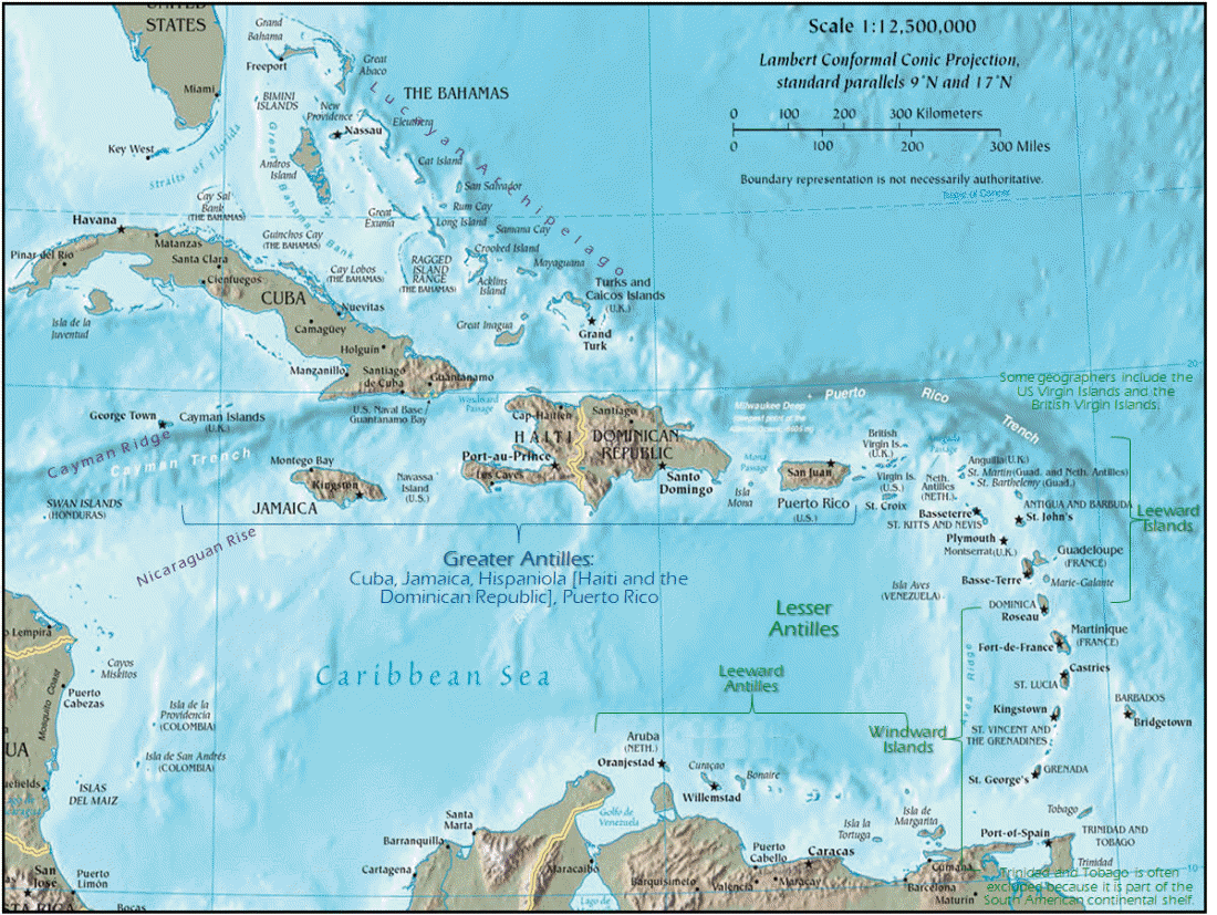


![The Caicos Islands (pronounced KAY-kohss) in the northern Caribbean are known for their beautiful beaches and clear waters. The islands lie primarily along the northern perimeter of the submerged Caicos Bank, a shallow limestone platform formed of sand, algae, and coral reefs covering 2,370 square miles. [NASA satellite photo]](../images/Caicos.gif)


 |
|


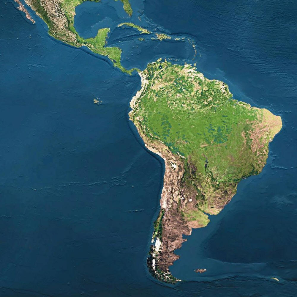


 river basins:


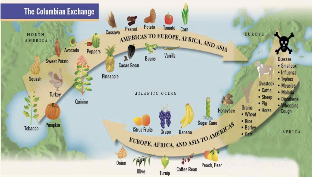

 Demographic Characteristics